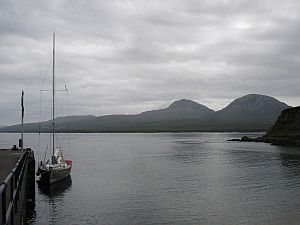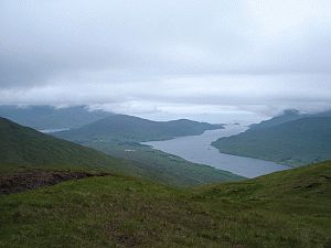
| 27 juin 2005 - Killary Harbour / Irlande - 53°36'N 9°43'W | |||||||||||||||||||||||||||||||||||||||||||||||||||||||||||||||
La preuve des forêts nous est donnée de façon remarquable par les nombreuses racines bien conservées dans les sols de tourbe acide qui à l'occasion se révèlent fort utiles pour traverser les marécages. Cette randonnée qui est 'vendue' par l'office de tourisme comme une ballade de découverte sauvage, se révèle comme proménade sur pâturage à moutons - chacun à ses échelles de valeur!
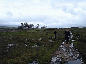
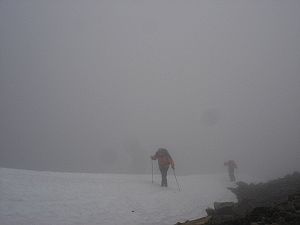
Au bout d'un bon moment d'ascension, nous faisons halte pour une pause de restauration. Depuis un moment nous progressons dans le brouillard et il fait froid. Par routine, nous vérifions nos altimètres et réalisons que nous sommes à 15 m du sommet: quelle surprise! Après quelques pas nous débouchons sur le plateau sommital: tout bascule. Des visiteurs des îles britanniques d'abord, du reste du monde après, font cette ascension comme un pélérinage. L'aspect du lieu en garde la trace: détritus en tout genre, bruit, un chemin d'accès pratiquement carrossable en 4x4.... Un peu déçus, nous attaquons la descente pour retrouver Imram quelques 1400 mètres plus bas. Berta nous attend avec une tortilla particulièrement succulente. Le lendemain sera une journée de repos. Changement d'équipage dans la nuit du 21 au 22 juin, le lendemain nous quittons définitivement le canal - enfin nous retrouvons notre liberté! Vents et courants sont favorables, enfin, on tire des bords comme d'habitude. Pendant l'après midi, nous faisons une brève halte à Oban, histoire de visiter la ville, sa distillerie (le tour guidé ressemble à un 'one-man show' Disneylandien dont la finalité est de faire vendre leur produit) ses magasins de glace et de bonbons. Nous larguons les amarres aussitôt pour pointer notre étrave vers des lieux plus calmes.
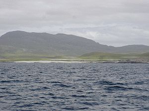
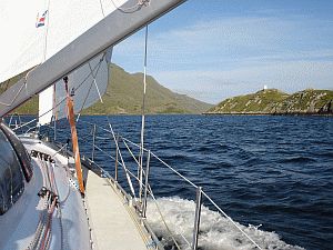
Le lendemain nous quittons le mouillage pour 40 milles de près qui nous permettront de rejoindre Loch Tarbert - lieu mystique et sauvage, d'une beauté exceptionnelle, caractéristique par ses plages suspendues, témoins d'un changement soudain du niveau de la mer, ses phoques et troupeaux de daims qui semblent nous souhaiter la bienvenue. Ici Imram croise aussi sa route vers le Nord, en 2003.
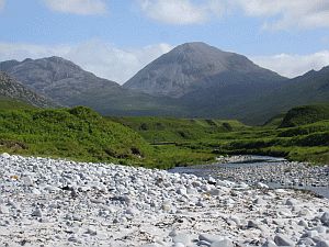
Aussitôt nous enfilons nos chaussures de montagne et gagnons la rive avec l'annexe. Sous le soleil bas de l'après midi, nos ombres se font longues et les couleurs intenses. Une marche d'approche parmi les troupeaux de daims nous amène au col entre les deux 'Paps'. Décision délicate: celui de gauche ou celui de droite? Tous les deux sont tentants et la seule information que nous possèdons est l'extrait de la carte marine recopié sur un bout de papier à la hâte. Le seul véritable argument est que celui de droite et plus haut que celui de gauche; alors nous décidons de gravir celui de gauche, le moins haut (de quelques mètres) - cela nous laisse une bonne raison de revenir un jour!
C'est une belle visite industrie-archéologique. Notre 'guide' répond avec sa passion à notre curiosité et nous fait découvrir en exclusivité le 'nouveau' whisky qui sortira d'ici 10-12 ans. une bonne raison de revenir! Nous sommes enchantés et largement réconciliés avec le whisky et n'hésitons pas de compléter la cave d'imram d'une bouteille adéquate, hélas à court de temps, car la marée n'attend pas et nous ne voulons pas la râter. A la sortie de la distillerie, l'épave d'un chalutier nous rappelle de façon pragmatique que la consommation du précieux liquide doit toujours se faire avec modération!
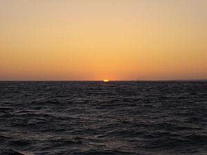
Afin de tenir notre calendrier, nous naviguerons la nuit. Le coucher de soleil est violent et donne lieu à un éclat vert, comme celui que nous avions expérimenté au Groenland, voici deux ans. Cependant la mer est agitée par un vent qui souffle par moments en grand frais et des courants également forts (>2nd), de nombreux bateaux dont nous croisons la route. Le lendemain, nous longeons déjà les côtes du NW de l'Irlande.
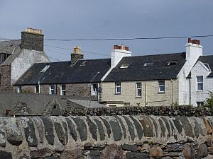
C'est toujours aussi verdoyant. Aucun arbre en vue. Quelques maisonettes, visiblement d'anciennes fermes, et des murs en pierre sèche marquent le paysage. Le temps est au soleil et les vents nous sommes favorables, malgré quelques courants dont la nature et la raison nous échappe par moments. Peu à peu le vent baisse, nous laissant sur une houle résiduelle courte et désagréable. Comme indiqué à juste titre dans le guide de navigation, un moteur puissant est un atoût quand le roulis vide les voiles du dernier peu de vent. La côte est découpée par de nombreuses baies et de multiples îles ilôts; bien sûr haut fonds et rochers sur lesquels la houle se brise bruyamment aussi. Il faut naviguer avec précision et nous saluons l'existence et la qualité des cartes et des instructions nautiques. Après une halte pour dégourdir nos jambes sur Aran Island, nous traversons la grande baie de Donegal afin de nous rendre sur la côte ouest. En plein nuit, alors que les quarts se succèdent, tantôt à la voile, tantôt appuyé par le moteur, nous sommes surpris un un groupe de dauphins qui nous accompagneront pendant près d'une demie heure, jouant autour du bateau et nageant par moments sur le dos pour inspecter la carène d'Imram, nous entendons leurs voix qu'ils utilisent pour communiquer. Le spectacle est des plus magnifiques, voir ces créatures élégantes nager sans effort à 8 noeuds, la vitesse du bateau, sautant hord de l'eau par moments, tout seuls ou à plusieurs, en suivant et en anticipant les mouvements du faisceau de lumière de notre lampe frontale et réalisant un ballet intime pour les deux équipiers de quart: difficile de se lasser du spectacle! La même équipe de quart connaîtra un deuxième spectacle une heure plus tard, toutefois d'une nature bien moins réjouissante, quand l'hélice s'enroule dans un filet de pêchers... Graçe au puits d'hélice qui permet d'intervenir sans plonger, l'incident est clos en un quart d'heure - nous n'osons pas imaginer l'opération qu'aurait nécessitée cet incident sur un bateau 'classique', sans parler des risques encourus par le plongeur avec un couteau aiguisé entre les dents dans l'obscurité par une mer agitée...
What has not been logged to create pastures, what has not been logged for local use or for exportation, is constantly eaten away. This impression we had been developing in the day was to be confirmed later on when we crossed a rare patch of land behind a high fence which was lush in ferns, high grass, shrubs, bushes... what most of these places should look like without sheep. Ben Nevis is finally in sight, after the first 20km of mud bath, and we decide to go up its East face. The view during the ascent is beautiful. First we cross a very nice valley with a river, invisible from the bottom, then climb up steep grass slopes and finally a long rocky section over the well-renowed local pink granite. We experience the four seasons several times, till Winter seems to settle and we go on in the cold and the fog, the usual conditions in this place. We take a break for a snack while wondering how far the top should still be and yet another look to the compass and the altimeter tells us it's just 15 meters above us... Once on the summit, and during the way down the "Normal way" we cannot hold back deception. The normal way can well be driven up, and the local crowd first and the foreigner crowds then seem to leave all possible kinds of litter behind them. Better to hurry up, eventually reaching Imram again after about 15 hours walking, and enjoy the tortilla which Berta had prepared for us. In the night between June 21 and 22 the new crew joins us, early in the morning of the 22 the locks finally open in front of Imram's bow and we sigh in relief: we are free again. The wind is with us, the current as well, and we sail to Oban, to visit the town and the local wisky distillery... talk about tourist traps. We feel trapped in a one-man-show aimed to peddle the products of a coalition of single malts, and after a few ice creams and sweets we cast off and reach a nice little bay, from where we can land and discover a beautiful bridge connecting apparently since the dawn of time one of these islands with the mainland. The place is beautiful and long gone are the times of our wild moorings in the North Atlantic... seven other boats share the place with us. Imram seems deceived by such a crowd and after some rest and recreation we cast off toward Jura, with its suspended beaches, eventually mooring in Loch Tarbert. The place is desert and fantastic. The local inhabitants, deer and seals, come to greet us at once and a few minutes after our arrival we are already in our mountain boots, following a river valley towards the Paps of Jura, the peaks in the middle of the island. The sun is low, the colour saturated, the shadows longer and longer. Deer and fawns often walk close to us and after a while we are at a col between two of the peaks. We have no map apart from the symbolic one we copied from the nautical chart and the only thing we know is that the left peak is lower than the right one. We decide to take the lower, to give ourselves a good reason to come here again. After a bit of uphill struggle in steep grass and some rocks, we are at the top.
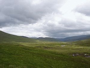
We have a fantastic view on much of the South West coast of Scotland:
He gives us detailed description of each stage of the production, he is so fascinated with his job that never fails to answer in details the many questions we ask and we are, in turn, fascinated with the magic of these places. We are not in a whisky Disneyland, this time, but almost on an industrial archeology tour. Things have hardly changed since 1881. The tour is followed by the traditional tasting and we are allowed to learn a small secret, a new version of their brew has been in preparation for the last few years and we can nose it... it has still a decade to go in barrels, but what we smelled is enough to decide to come back then! Time to leave, till the tide is with us, currents in this Sound are strong, and a wreck just around a landtip after the distillery is a good warning about it. A short, last, stop in Scotland is in Port Ellen for some small repairs and yet another example of the charming hospitality we have met with everywhere in these lands and off we go to Ireland. The sea is a bit rough, the wind is strong with near gale force at times, Imram does not stop surprising us with her speed and stability. Before the nightfall, the sun sets among the Hebrides, and we get the farewell present from Scotland, an impressive green flare just after the sunset, reminding us of the one we saw two years ago in Greenland. Mile after mile, watch after watch, next morning sees us to along the NW coast of Ireland.
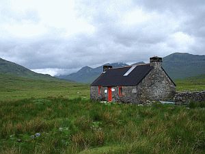
Everything is green, as expected. No trees to be seen, as in Scotland. Small stone houses and long stone walls over the hills which dive into the sea. The wind is with us, the sun shines, and the conditions are good, apart from some strong, mysterious currents which we meet from time to time and some residual swell which does not make life onboard very pleasant. The coast is continuosly cut by bays, full of islands and islets, not to mention rocks, where the swell suddenly breaks. We negotiate them with care and concentration, thanks to the excellent quality of the charts and nautical instructions. A short stop on Aran island, time to walk around its turf-digging installation, the remote cliffs, and trade 10 kg of crab legs, whose value we dare not calculating, against a bar of swiss chocolate (elsewhere worth five big fish, or a pot of wood varnish...). Watch after watch we sail a full day, toward the West coast. The night watch of Peter and Salvatore was the most eventful. At about 0230, ten dolphins come closer and closer to Imram. They start swimming at 8 knots, our speed, apparently effortless. They like to circle the boat, and for about half an hour they play with us. They aline themselves to the bow, swimming in one or two lines below it, sometime even upside down. They jump just in front of us, or cross below the boat. We can hear them "whistling" to each other, like they wanted to tell us something... we try to communicate with a light, moving it from a side to the other to the boat, and they enjoy trying to reach it as fast as they can, and sometime anticipate its regular movements. An unforgettable night which made us really feel part of this marine environment in which we have lived now for more than a month.
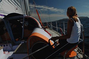
Sun rises and we are met by bright blueconditions with a light
NW wind just right for stopping it from getting too hot and for
filling the spinnaker. Imram smoothly glides at 6, 7 sometimes 8
knots in these light winds. A lunch of tuna salad, freshly baked
bread, white wine and Irish coffee, is served while the islands
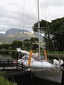
and coastline of Eire's County Mayo gently slip past. We enter Killary
Harbour for a beautiful anchorage in Ireland's only fjord.... this
is not Norway and comparisons are not in order. We enjoy the beautiful
green hills, to be climbed next day, and a well deserved night of
sleep after operations were undertaken to repair the engine cover
and to remove three ticks that Philip had unknowingly acquired while
walking the Paps of Jura. Rob's experience of dealing with dog ticks
proved useful so, with the help of a red-hot split pin, a Stanley
knife and plenty of patience, the unwelcome guests were evicted. Précédent | Index 2005 | Suite/next The
Imram Voyage 2005 - Integral 12.50 - ACAPELA, 2004 |