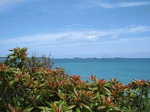
| 4 juillet 2005 - Hugh Town / Scilly Islands - 49°55'N 6°19'W | ||||||||||||||||||||||||||||||||||||||||||||||||
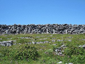
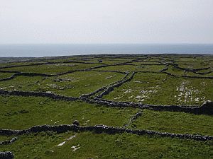
Sur le coup, impossible de localiser précisement l'orgine de l'odeur d'appareil électrique surchauffé, d'abord discrètement, puis de plus en plus fort accompagné d'une fumée blanche émanant de la sortie de ventilation du compartiment moteur. Une bonne brise risque de nous drosser sur les rochers de la côte à deux encablures (1 encablure = 1/10 de mille = 185m) si le moteur venait à caler, à moins qu'on envoie les voiles en un temps record. Demi-tour donc et amarrage in extremis avant que le moteur ne cale - court-circuit d'alimentation électrique. Grosse frayeur mais petits dégâts seulement - heureusement - le bobinage du démarreur a fondu ce qui nous met momentanément en panne de moteur. Bien que manoeuvrants à la voile seule, nous n'envisageons pas de nous engager entre les cailloux de la côte bretonne à la voile seule, au cas où une panne de vent survenait... Nous donc voici, 'cloués' sur les îles Scilly, ce qui n'est pas pour déplaire car l'endroit est charmant et cette attente nous permet de découvrir les lieux entre promenades sur les îles (St. Mary's, Tresco, St. Agnes) et visites des hauts lieux gastronomiques: pasties, cream tea et stouts... Entre deux averses, le soleil est au rendez-vous: du beau temps estival, temps à la baignade! Revenons quelques jours en arrière: Après une nuit confortable et silencieuse à Killary Harbour (voir récit précédent), ce fjord irlandais dont nous inspecterons brièvement les environs à pied, nous larguons l'unique amarre qui nous relie à la bouée, cap sur les Aran Island que nous atteignons à 2 heures du matin, sous une voûte celeste étoilée magnifique comme il n'y en a qu'en été aux basses latitudes. Eh oui, après le soleil de minuit nous redécouvrons la splendeurs des nuits estivales. A l'arrivée, nous nous rendons à l'évidence que notre guindeau est hors d'usage, apparamment un problème d'engrenage que nous ne pouvons résoudre par les moyens du bord. Par chance des bouées d'amarrage sont prévues. Après un court sommeil et un copieux petit déjeuner, nous partons à pied, visiter l'île dont le charme n'est pas sans rappeler certaines îles méditerranéennes par le soleil radieux, la brise chaude et le sol sec. Des centaines de kilomètres de murets construits par des générations structurent le paysage. Le sol est constitué de lapiaz, roche calcaire érodée par le ruissellement de la pluie en plaques séparées par de profondes crevasses, des fois aux bords tranchants. Au fil du temps, les habitants ont bouché ces failles et ont apporté algues et autres matières organiques permettant de constituer une couche végétale propice à l'épanouissement de l'herbe et du bétail.
Nous nous trouvons précisément sur les traces de ces moines qui s'exilaient sur des lieux invraisemblables en quête de spiritualité et de paix, ces mêmes moines qui dans cette quête ont 'découvert' de nombreuses îles de l'Atlantique nord. La légende la plus vivante est l'Imrama de Brendan, légende qui nous est rapportée du 5ème siècle, histoire d'un voyage aventureux à travers l'Atlantique nord d'un moine et de ses disciples qui leur fera découvrir des lieux fascinants, lieux qui pourraient se rattacher au îles Féroé, l'Islande, vraisemblablement la banquise arctique et pêut être même le Groenland et Terreneuve - un récit qui n'inspire pas seulement le nom de notre bateau: Imram, mais aussi une partie du parcours de notre voyage, de notre Imrama contemporaine.
A présent, il ne nous reste plus qu'à faire preuve de patience en attendant l'arrivée de l'hélicoptère avec le nouveau démarreur, ensuite le remonter et glisser vers St. Malo. Ainsi la boucle sera bouclée: St. Malo - St.Malo en 12'000 milles, 28 semaines d'une expérience et aventure unique qui nous auront fait découvrir des lieux peu fréquentés, nous faire prendre conscience de l'extraordinaire richesse, beauté mais aussi fragilité du bassin atlantique arctique, terreau aussi à de nouveaux rêves et projets - histoire à suive... mais ce sera une autre histoire.
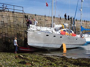
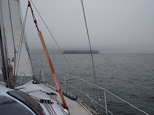
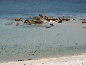
Shortly after leaving our harbour mooring, there was a whiff of something strange in the air. The first suspicion was an overheating computer, but then we noticed that the engine exhaust was tainted with unpleasant-looking white smoke. Now, as many a sailor saying goes, boats are built to take the water, not the fire, and a fire onboard is still the single most likely cause of (huge) troubles at sea. This called for the engine to be stopped as soon as possible. The situation was further complicated by a good breeze which pushed us toward the rocks at two cables (which is about 350 meters) from the shore. Time for fast decisions. We did not try to hoist the sails at record speed and make it back for the harbour. While doing so, the smoke got worse, which made it impossible to get to a mooring buoy, as the engine had to be switched off there and then. We approached and tied up to the local, sturdy, pilot boat, conveniently moored at the entry of the bay. A pleasent engine exercise in settled weather, but a nerve-wrecking experience with the engine shut off, using just the residual speed of the boat, with an unpleasent swell to make matters more tricky. After the succesful maneuvre, towing was requested and obtained, and we reached our present position, tied up to the last part of the quay of the harbour, which dries up twice a day, in the local four-something meters of tide. The experience was frightening, but the damages small. The failure was localised in the starter motor. This means we cannot switch it on again and, even though completely effective under sail, we prefer to get this fixed before the crossing of the English Channel: a sudden drop of wind close to the rocky shores of Brittany, known for its currents, is not an experience we want to live. Unfortunately, starter motors are not the easiest commodities to come by on a Saturday afternoon on the Scillies. So here we are, stuck half in and half out of the water, like a stranded whale. Fortunately the weather is mainly gorgeous, and the comments of tourists idling along the quayside ("Do you think they know they're resting on the sea bed?" and "Lucky they've got those orange boards on the side to stop the boat falling over!") keep us amused. Most are convinced that Imram's design is revolutionary, especially as the rudders had to be removed in the drying-out process "But how on earth do you steer this boat - no wheel, no rudder??". But, to complete our -last- logbook, let's start with the beginning. After a comfortable and silent night in fjord-like Killary Harbour,
and a walk up the hills which border it, we set course toward the
Aran Islands, where we arrived at 2 am, after a very pleasent navigation
under a starry night. After having been spoiled by the midnight
sun, we are, little by little, as our latitude decrease, re-discovering
the pleasure of the summer nights. The arrival in Inishmore was
coloured by the discovery that we could not anchor, as the anchor
winch seemed to be out of order. Luckly, visitor mooring buoys were
available, which allowed us to land and discover, next day, this
strange place, which, Although just a few kilometres across, the island is criss-crossed by hundreds of kilometers of dry walls, about a meter thick, built hundreds of years ago. Their function is to create some soil to allow some subsistence agriculture off the dry limestone of the ground. Generation after generation, seaweed was collected, dried, and placed with sand between the walls, giving, still now, a pasture enjoyed by the rare sheep and cattle owned by those who did not turn to the tourist industry.
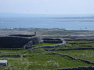
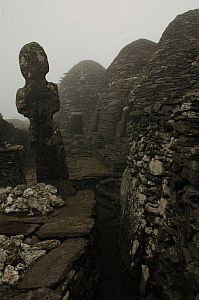
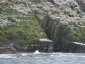
Indeed, the island boosts some forts dating back two or more millennia, of whose original builders little is reallyknown, which attract a large number of visitors, shepherded around by bike, minibus or horse-drawn carts. Luckly, we have chosen the long way to visit the island and profiting from the clement weather, we can follow, and sometime climb, the cliffs of its side, a fantastic landscape of sharp edges which have somewhat resisted the fury of the Atlantic ocean since ever, or so it seems. It is a long walk which we enjoy through most of the day and straight back to the boat we cast off again: the weather will not stay this nice for ever and wisedom suggests to clear the West coast of Ireland nowshould things turn for the worse. En route for the South we attempt a landing on Skellig Michael. This tiny island, a few miles from the shore, is a magic place. More than 200m high, and just few hundred meters across, it is capped by a monastery, and nothing other than puffins, seagulls, gannets and other marine birds. A stairway roughly cut into the rocks allows us to climb the sheer and humid rock faces, reaching the tiny beehive huts that hosted a few monks fifteen centuries ago and are now laid to rest in a tiny, evocative, graveyard. This place survived Viking raids, inclement weather, and each stone cut in place more than a millenium ago seems to have seen many stories nobody will ever tell.
The only thing we see, approching the island shortly after sunrise, is the first fifty or so meters of coast, since a thick layer of cloud hides the rest in a mist which seems appropriate to this mystic place. Some of us land, with a nerve-wrecking approach: the only way to get on land is a natural bay which is only slightly larger than Imram, and basically as long as she is, with things made more difficult by some swell. A quick jump, and off we go to climb this island clad in mist and history, while those on board, circling the island, live an emotional moment, sort of an epiphany, realising that Imram is now really in the waters and in the traces of her namesake. Nous nous trouvons précisément sur les traces de ces moines qui s'exilaient sur des lieux invraisemblables en quête de spiritualité et de paix, ces mêmes moines qui dans cette quête ont 'découvert' de nombreuses îles de l'Atlantique nord. La légende la plus vivante est l'Imrama de Brendan, légende qui nous est rapportée du 5ème siècle, histoire d'un voyage aventureux à travers l'Atlantique nord d'un moine et de ses disciples qui leur fera découvrir des lieux fascinants, lieux qui pourraient se rattacher au îles Féroé, l'Islande, vraisemblablement la banquise arctique et pêut être même le Groenland et Terreneuve - un récit qui n'inspire pas seulement le nom de notre bateau: Imram, mais aussi une partie du parcours de notre voyage, de notre Imrama contemporaine.
It is the history of an adventurous travel across the North Atlantic of a monk, Brendan, and his followers, through fascinating sites which we could identify with the Faroe Islands, Iceland, maybe the Arctic ice shelf or even Greenland or Newfoundland. It is indeed from this tale that Imram (which has the meaning of 'to row about') takes her name, and our trip around the island of the North Atlantic takes its inspiration. Travels into the mysteries, something that, in front of the stairways into the mist which still clads the top of Skelling Michael, sends chills down your spine.
Soon, our engine will be operational again, and we will eventually set sail toward St. Malo. Once there, our trip will be over, this time for good. We will have covered, from St. Malo to St. Malo,12000 miles. An adventure of 28 weeks over three years, which changed, somewhat our lives. We had the privilage of discovering little-visited places of the North Atlantic. We experienced a harsh, sometimes threathening, yet fragile, environment. We sailed in the traces of generations of explorers, who, from the sea, saw and explored these lands over centuries. However, the end of this extraordinary adventure is the just the start for new dreams. We are confident that these dreams will soon turn into projects and, eventually, other stories which await to be told.
The
Imram Voyage 2005 - Integral 12.50 - ACAPELA, 2005 |