Narsaq - Sisimiut
 Siorak (62°28.8'N 50°19.0'W): Good hold in
sandy ground protected by the little islets to the
S. Not recommended unless the weather is calm and
setteled. Possibility to make a short visit onto the
amazing sand beaches. The inland route lacks bearings
and is exposed to the wind and waves from the W. Charts
are approximate and not in accordance with GPS positioning.
Kare must be taken.
Siorak (62°28.8'N 50°19.0'W): Good hold in
sandy ground protected by the little islets to the
S. Not recommended unless the weather is calm and
setteled. Possibility to make a short visit onto the
amazing sand beaches. The inland route lacks bearings
and is exposed to the wind and waves from the W. Charts
are approximate and not in accordance with GPS positioning.
Kare must be taken.
Tovkussaq (64°52.8'N 52°11.8'W): Good hold
to the N of the bay in 5-10m sandy bottom. Fresh water
can be obtained at a small waterfall to the W of the
bay (metal ring in the neighbouring rocks).
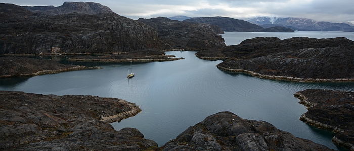
Tasuissaq (65°34.8'N 52°46.2'W):
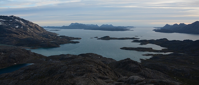
View to the West, Nanuq is the
small dot to the bottem right of the bay (photo Kalle
Schmidt)
Good hold to the NNE of the bay in 10m sandy ground.
Beautiful hiking in the surroundings with breathtaking
view to the W. Close to Manitsoq. Very alpine.
Iserkuq (fjord). Several mooring possibilities, one
of them being 'Jak's Bay' (66°07.4'N 53°36.4'W):
Good hold to the S of the bay in 18M muddy ground.
Small waterfall to the W of the bay with metal ring.
Very rocky and arid surroundings.
Sisimiut - Upernavik
Sydbay (67°13'N 53°53'W): In contrary to the
instructions found in Imray, the anchorage to the
N is not strong enough for strong winds (20knots)
from the S (to deep and to many algae). Excellent
hold can be found to the W of Ukivik in 12m sandy
ground. Protected by several awash rocks to the SW
of the island. Visiting the island is recommended:
the view from the light house and the the well conserved
turf house are worthwile.
Ikerasarsuq (68°08'N 53°27'W): The rocky and
deep bottom is not suited for mooring. There is however
a little peer suited for a short stop. The small village
lies out of the way of the main touristic route.
Hunde Ejland (68°52' 53°07'W): Small unvisited
village situated on an archipielago at the entrance
to Disko Bay. Approach to the little harbour through
the N/S channel to the E of the archipielago. Aim
towards the little peer to the W, avoiding the visible
rocks. There are some 6m shoals. Fresh water is produced
by reverse osmosis.
Bredebugt (69°16'N 50°58'W): Small bay on
the S side of the main bay, 5M to the N of Ilullisat.
Good hold in 6-8m sandy bottom. Depth close to shore
is around 5m. Size limit, the use of land lines may
be recommended.
Sarqaq (70°00'N 51°57'W): good anchorage inside
the little bay to the S of the small village. Protected
to the S by a little island and 1m shoal. Excellent
hold in sandy bottom (5-10m). Fuel available on the
peer. Small shop. Nosy-Bé wintered here in
1996. Well charted.
Temporary mooring to the S of Nugsuata (70°40'N
54°34'W): well protected from the dominant winds
from NW and SE. Open to the sea to the S and W. Good
hold in rocky ground covered with algae (11m), close
to a pebble beach at the foot of a stone wall. Volcanic
origin. Surrounded by beautiful valleys, with mushrooms
and berries. Some Inuit tombs.
Niaqornat (70°47'N 54°34'W): Small village
installed on an isthmus. Beautiful surroundings with
great hiking possibilities. The mooring is situated
on the W of the isthmus. Good hold in calm weather
in 15m sandy bottom around 15m from the beach. Open
to the NW and only protected by big icebergs grounded
on the shallow bottom.
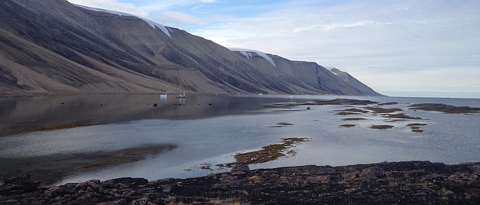
Mooring to the S of a glacier 'moraine' at the W entrance
of Amitsup Suvdlua (71°49'N 55°24'W):
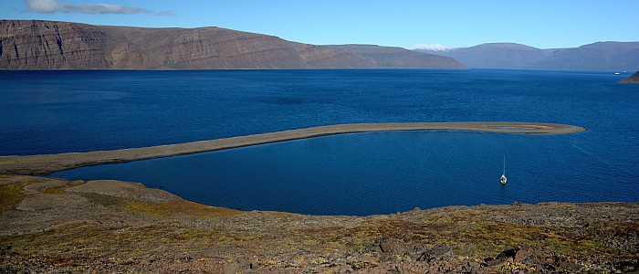
View of the mooring looking East
(photo Kalle Schmidt)
Good hold in 10m sandy/algae ground. On the shore
there is an old hunting cabin. The 'moraine' is not
shown on charts but can be seen on satellite images.
Arid surroundings, amazing hiking terrain! Close to
the beach there are some rests of turf houses and
a tipi camp.
Upernavik region
Isfjord, island without name (72°48.2N 54°15.5W):
13m deep, fine sand ground. Good hold for anchor in
good weather. Possibility to access the Ice-Cap. Beautiful
sight onto glacier.
Fjord without name (72°48.2N 54°15.5W): very
good mooring protected from the wind and the ice.
Sandy/muddy ground with good hold (algae can be avoided).
The end of the fjord is accessible with some local
knowledge (rocks in the passage - pre-sounding with
dinghy recommended). The little bay at the end of
the fjord is potentially an all weather/all year round
mooring place. Fresh water stream close by, on the
exposed S side of the bay. There seem to be some rests
of a summer camp of local fishermen. The big waterfall
shown in the N of the fjord no longer exists.
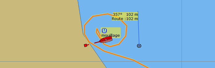
Appilattoq village (72°52.3N 55°34.2W):
Vue du mouillage vers le Sud,
la passe d'entrée est à droite (photo
Kalle Schmidt)
Excellent small natural harbour used by local fishermen.
Good hold in the middle of the main basin at 13m,
in sandy ground (depths vary between 6-18m). Approach
from the W through a narrow passage. It is recommended
to stay in the middle (8m), as there are some rocks
to both sides close to the shore. Care should be taken
when moving inside of the bay as there are some isolated
underwater rocks in the main bay and the passage leading
to the smaller bay to the E. Fresh water lake 15'
away by foot. Distance to inhabited village ~2km -
easy walk. GSM connection.
Atiligssuaq (72°46.9N 55°51.4W): small bay
perpendicular to the main fjord. Well protected from
the predominant winds. Sandy ground (unverified hold).
Good mooring can be obtained by anchoring in 12-15m
water and attaching two lines to the shore.
Bay to the South of Umiasugssuk (72°45.8N 55°53.9W):
good anchorage on sandy/rocky ground. Small beach
on the S of the rocky isthmus that closes the bay
to the NW. Steep mountains on both sides of the bay.
Many climbing possibilities. Several waterfalls in
the surroundings. Old snow at sea level (August).
Quite visited by locals. Avoid mooring to close to
the flanks of the mountains, danger of falling rocks!
Nutaamiut (73°31.1N 56°25.1W) : Village marked
as disused on charts but inhabited: new infrastructure
(fishing factory, GSM antenna, houses). Anchorage
can be found to the E of the GSM Relay antenna (50m
from the chapel) at 0.2nm from the cost. Sandy/rocky
ground, 6m deep. Caution is advised, there are some
shallower spots. There is no peer, but a protected
stone wall equipped with rubber tyres at the foot
of the crane to the S of the village. The anchorage
is not well protected from ice although shallow bottom
keeps big icebergs away.
Qaanaaq region (Thule)
Barden Bugt (77°08.7N 70°43.1W): landlocked
mooring with excellent hold in 15m sandy ground, aprox.
80m from the beach at the end of the fjord behind
a 'moraine'. Keep clear of shoals close to the different
'moraines' and Kap Powlett. Remains of an abandonned
village along the N coast of the fjord. Glacier landscape.
Over night there is a cold breeze blowing from the
glacier. A potential winter camp mooring? To be tested
in strong winds from the W (uncomfortable swell from
the side may occur).
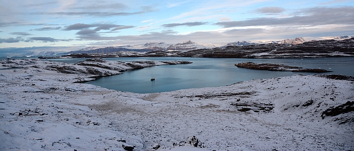
Qeqertarssuaq (77°25.4N 70°14.0W):
Mouillage à l'ouest du
villiage abandonné de Qeqertarsuaq; vue vers
l'ouest (photo Kalle Schmidt)
Good hold in 5m sandy ground in a little bay open
to the NW (find a spot between the algae). Make a
big turn around the W of the islets that close the
bay to the N to avoid underwater rocks in the axis
of the islets. Do not go further into the bay as the
Islet to the W, there are numerous rocks! The end
of the bay is dry at low tide. The abandoned village
is 1.5km to the E of the mooring. There are several
turf ruins along the coast.
Fan Gletscher (77°32.5N 69°54.8W): mooring
to the W of the delta formed by the streams coming
form the glacier, opposite of Herbert Oe. Excellent
hold in 7m sandy ground. Open to the S.
Qaanaaq (77°27.9N 69°16.6W):
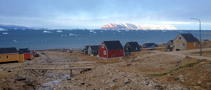
View from Qaanaaq to the South-West,
Nanuq and Herbert Oe in the distance (photo Kalle Schmidt)
Very good hold in 5m in sandy ground. 5-6 cables
to the W of the village. Protected by some underwater
rocks that are visible at low tide forming a small
bay, providing shelter from the drifting ice. The
approach is though a narrow passage, 2.0 to 2.5m depth
at low tide, 77°27.8N 69°17.0W coming from
the S. The depth in the bay is around 5m. No protection
from the wind nor some swell at high tide. Access
to shore by dinghy on the beach towards the village.
3/4G network. Don't miss à stop at Qaanaaq
Hotel!
Inglefield Bredning
Open from the middle of July to the beginning of
October. Spring tides are of about 3m, half for neap
tides. Communication in the region on VHF channel
10. No link with Asiaat Radio.
The entrance of the fjord is exposed to strong winds
from North and South. Very strong gusts will fall
down from the mountains This should be taken into
account when mooring. The head of the fjord is exposed
only to gales from the South. They can be very strong.
We have experienced wind speeds above 70 knots.
Sailing to the E of Qaanaaq requires a special permission.
Ask at the Kommunia for help. It is also advised to
check with local hunters, as to avoid disturbing them
in their activities.
Kangerdharssuk (77°33'N 68°35'W): anchorage
in 15m sandy/muddy ground. Good hold to the S of the
delta. There is just enough space to swing around
the anchor with reasonable distance to the shore (20-40m).
Good protection except from the N to E. In SE gales
ice drifts into the bay. In this case; a temporary
anchorage may be found on the opposite shore of the
fjord below the mountains at the S end of the delta
- very steep but good hold. Rich flora. There are
a few huts used by local hunters and rests of a disused
village. Easy access to the Piulip Nunaa ice cap.
Alpine landscape.
Harward Oer (77°29.5'N 66°29.3'W):
View of the mooring towards North-West
(photo Kalle Schmidt)
The anchorage is situated 2.5 miles to the E of Qeqertat.
Good hold in sandy/muddy ground. Protected from the
ice and the heavy sea in all directions, but not sheltered
from the wind because of the low surroundings. Stay
in the middle to cross the bay that separates the
N and the S island. Depths not less than 10m. For
the approach from the W: Round the S of the little
islets (77°29N 66°42W) close to the village
of Qeqertat. Access to the mooring from the N. 45min
hike to the highest point of the archipelago (numerous
little fresh water lakes).
Harward Oer (77°30.4'N 66°24.6'W): excellent
mooring in a closed bay 4M to the E of Qeqertat. Depths
between 8 and 25m. Good hold in sandy/muddy ground.
The best protection from southerly winds can be found
to the S of the bay, just to the W of the entry passage
(moor in 15m depth and tie two land lines to the rocks
to the S). Keep clear of the drying rocks all around
the shore at a distance of 20-40m.
Caution: underwater rocks to the SW of the entrance,
aprox 50m from the shore. Green landscape. 15min hike
towards the E to a high point with a view onto the
vast end of the fjord.
Harward Oer 77°29.5'N 66°33,5'W : there are
numerous mooring possibilities in this natural harbour
which is situated between the two main islands of
Harward Oer. The bay we unofficially call 'Nanuq's
Cove' can only be used with landlines. Protection
from S-ales is good, from the North slightly less.
Winds from E and W are moderate. There are several
drying rocks in the center of the bay. Further inside
the ground is not deep enough. Therefore it is convenient
to attach two landlines to the N and two to the S,
close to the entry of the cove. Strong straps (such
as used on cargos) are perfect to make a good anchor
around big rocks. 200m of mooring line are advised.
The depth in the entry is around 3m. There is a deep
lake at about 1km to the SE, with clear fresh water
to fill up fresh water tanks. The landscape is breathtaking
with many different hiking possibilities. The distance
to the village, Qeqertat, is 2.5km in a straight line,
but you need a dingy to cross the bay (if not frozen).
|