|
This page
is a catch-all for useful or just interesting information
... that has been useful to us for the preparation and making
this voyage. Yet, there still is huge space for the unknown
... If you think we missed something important, please let
us know.
What
is the Arctic
Definition
Arctic
comes from the Greek 'arktos', the bear - not the polar bear
(Ursus Maritimus), but the constellations of the great and
the small bear that characterize its heaven.
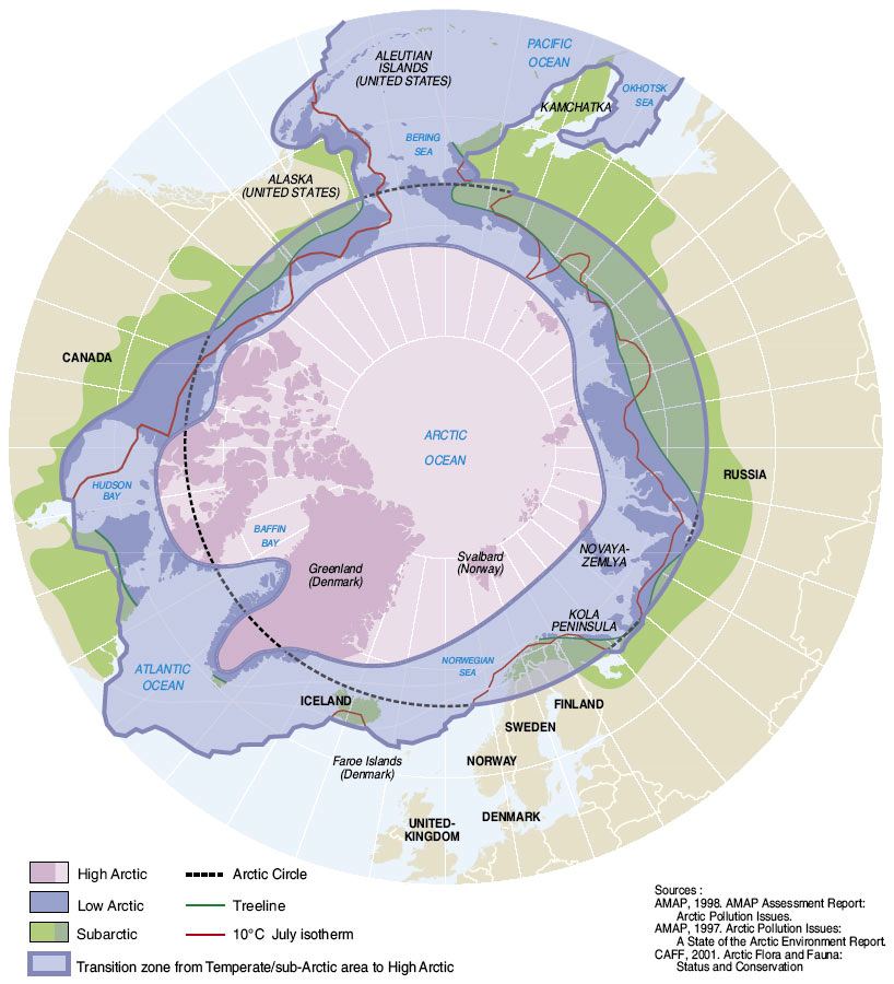
The Arctic
is roughly the area between the Arctic Circle and the geographic
North Pole. More detailed definitions rely on climate observations,
eg the isotherm of +10 ° C in July from where trees will
no longer grow ...
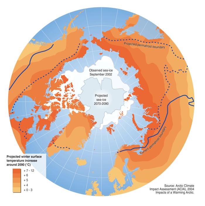
The Arctic
is the refrigerator that helps regulate the climate of the
earth. Any disturbance is felt globally. It is in the Arctic
where we are witnessing the most dramatic global warming.
The melting of the Greenland ice sheet would raise ocean waters
of 7 meters and directly affect all coastal areas ... see
this simulation
This could
occur; see the observation of the Greenland
Ice Sheet
Map source
: AMAP
Arctic Monitoring and Assessment Programme
Best maps and GIS
Maps of Norway:
Maps of Svalbard:
Maps of Iceland:
Maps of Greenland:
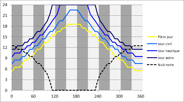
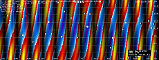
Lenght
of day and twilight in the Arctic
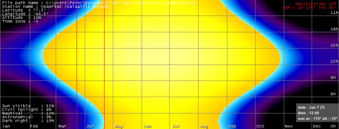
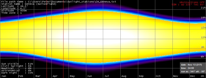
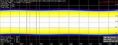
Twilight and sun in Qeqertat - horizontal
axis = date; vertical axis = time (application 'twilight'
- Peter Gallinelli)
Part of
what make the Arctis specific is the very special day - night
pattern. In opposition to a widely spread idea, there is more
daylight in the Arctic than anywhere else in the world. Whilst
potential sunshine hours are the same at any location on earth
(aproximately 50%), one will observe only 20% of dark night
at 77° North, half of what occurs close to the equator.
Of course this is applicable also to the far South. The effect
is even more amplified due to the high reflectivity of of
snow and ice (albedo).
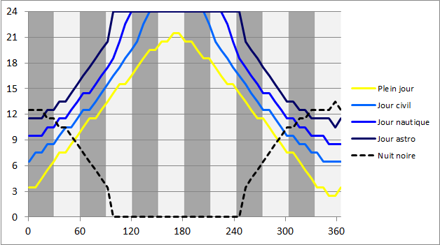
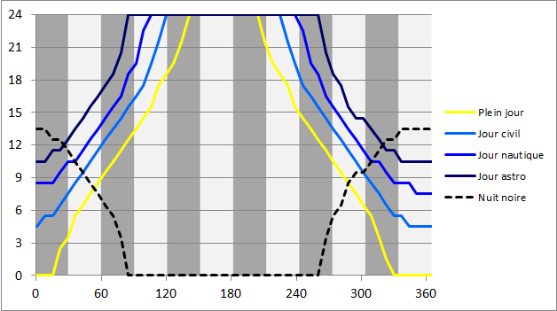
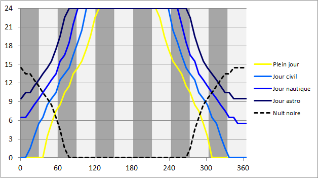
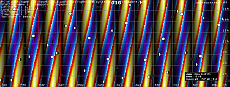
Annual
graphs for latitudes 60°N, 65°N, 70°N, 75°N
: click to enlarge
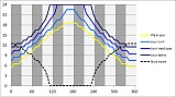
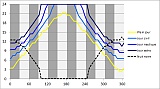
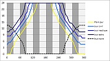
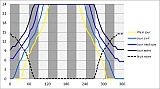
The free Twilight program calculates annual graphs
for any location on earth ... have a look here.
What does the arctic night look like?
You may try to imagine the arctic night with information
concerning sunrise, sunset, moonrise, moonset and twilight
in the tables here below.
There are 3 types of twilight:
 Definition
> Wiki Definition
> Wiki
Civil Twilight: is from sunset to the time
at which the sun is 6° below the horizon. At this time,
there is enough light for objects to be clearly distinguishable
without artificial illumination. Civil twilight is the definition
of twilight most widely used by the general public. Navigation
by sight is generally possible till the end of civil twilight.
Nautical Twilight: is the time when the centre
of the sun is 12° below the horizon, and only general
or vague outlines of objects are visible, when it becomes
too difficult to perceive the horizon. This term goes back
to the days when sailing ships navigated by using the stars.
The use of a sextant to measure the altitude angle of stars
required horizon visibility.
Astronomical Twilight: is the time at which
the sun is 18° below the horizon. It is that point in
time at which the sun starts lightening the sky. During the
evening, this is the point where the sky completely turns
dark.
Light is of course only available when the sky is clear...
Useful tables
| sunrise - sunset |
|
|
| moonrise - moonset |
|
|
| civil twilight |
|
|
| nautical twilight |
|
|
| astronomical twilight |
|
|
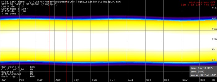
Source of data : U.S.Naval Observatory, http://aa.usno.navy.mil/data/docs/RS_OneYear.php
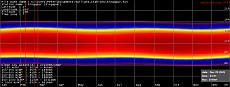
The graphs here below show the contents of the tables in
a more colorful way: horizontal axis = date, vertical axis
= time
 |
 |
 |
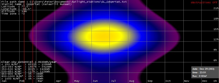
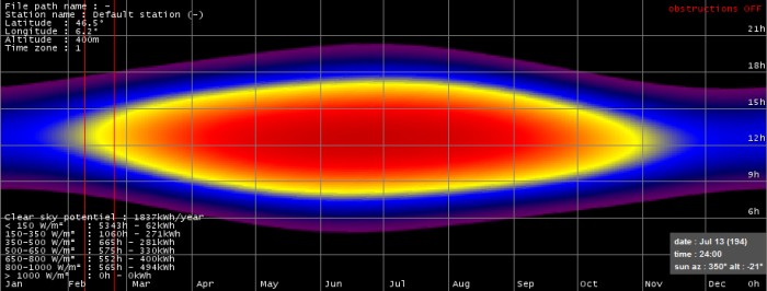
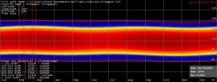
| Qeqertat
: latitude 77.5°N |
Central
Europe : latitude 46.5°N |
Singapor:
latitude 2°N |
But of course light is not equal to solar energy. Due to
the low sun altitude solar flux is limited. This is the main
reason why the Arctic is cold. Here below the same tables
with calculated clear sky solar fluxes:
 |
 |
 |
| Qeqertat
: latitude 77.5°N |
Central
Europe : latitude 46.5°N |
Singapor:
latitude 2°N |
We didn't expect that the moon would not rise or set for
long periods. But this is perfectly normal above 70° latitude.
 |
 |
 |
| Qeqertat
: latitude 77.5°N |
Central
Europe : latitude 46.5°N |
Singapor:
latitude 2°N |
During the arctic night the moon is of big importance. The
full moon periods are magical; the amplification of the moon
shine by snow and ice put the scenery of the north into an
intense blue light. This is konwn as 'blue moon'. When there
is complete darkness, one will witness the most impressive
sta rlight, and depending on location and time, one is likely
to see northern lights. During summer you will experince the
other extreme. You will see neither stars nor northern lights;
even though present all year long they cannot bee seen due
to the intense daylight lasting 24/7.
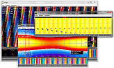
The graphs here above are made with the free Twilight
program that calculates twilight, moon shine and solar energy
for any location on earth ... to zoom in and more information,
follow this link.
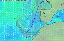
Weather
Some links
to follow actual weather and forecasts ...
Animated
forecast : overview
Animated weather : Windy
Marine
| Service |
I |
II |
III |
| NOAA |
|
|
|
| BRACKNELL |
|
|
|
| GMDSS |
|
|
|
| Westwind |
|
|
|
| |
|
|
|
Ground
| Station |
Altitude |
Latitude |
Longitude |
| |
463
m |
45.93
°N |
6.11
°E |
| |
7
m |
63.79
°N |
20.28
°E |
| |
138
m |
64.09
°N |
21.82
°W |
| |
86
m |
64.19
°N |
51.68
°W |
| |
61
m |
72.69
°N |
77.97
°W |
| |
77
m |
76.53
°N |
68.75
°W |
Boat routing
software
qtVlm
is a weather routing software for virtual and real sailing
boats.
A great GPL
licensed routing software : Virtual
Loup de Mer : uses 7 days GRIB files and much more...
 (f)
(f)
Weather
FAX on sea
JWX is
a Java short-wave weatherfax receiver/converter
A great GPL
licensed software : JWX
: connects to a quality short wave receiver ...
 (e)
(e)
The Beaufort
scale...
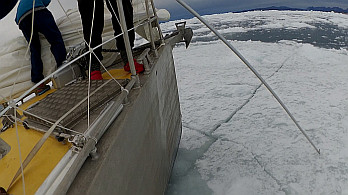
Ice
Presence of ice is one of the main features of the arctic
... and a constraint. A vessel such as the Integral 60 is
strong, but only 20 tons displacement make it possible to
break trough barely 10 to 15cm of ice ... when conditions
are good. In any case, we compose with and
not against nature...
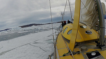
Nanuq in Upernavik's isfjord, august
2016
Ice poles are useful to position the bow, not to push away
ice floes...
Documentation
Estimation
of ice thickness
Relationship between accumulated frost degree days (0°C)
and ice thickness (cm)
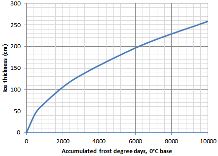
After Bowditch Practical Navigator,
Fig.3304b.
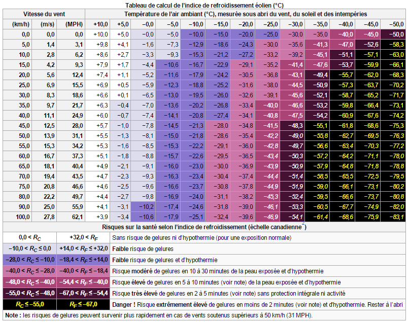
Wind
chill
Cold +
WInd = Danger
Here below
is a table that estimates wind chill, valid on bare skin.
Corollary : protect yourself!
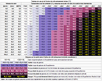 clic to zoom
Table extracted
from : Refroidissement éolien. (2014, novembre 14).
Wikipédia, l'encyclopédie libre. Page consultée
le 22:28, avril 11, 2015 à partir de http://fr.wikipedia.org/w/index.php?title=Refroidissement_%C3%A9olien&oldid=109110992.
Hypothermia
and frostbite :
Signs and Symptoms of Hypothermia
Shivering (may be absent in later stages)
Numbness
Lack of coordination
Confused or unusual behaviour
Body temperature below 35º C (95º F)
First Aid
Remove any wet clothing and dry the casualty
Warm the person gradually by wrapping him or her in sleeping
bags and dry clothing
If available, use heat sources such as hot water bottles
or heating pads to assist warming avoid direct contact with
skin), or use body heat
If the casualty is alert, give warm liquids to drink
Get medical attention as soon as possible
Signs and Symptoms of Frostbite
Shivering (may be absent in later stages)
Lack of feeling in the affected area
Skin that appears waxy
Skin that is cold to the touch
Skin that is discoloured (flushed, white, yellow, blue)
First Aid
Cover the affected area
Handle the area gently - do not rub!
Warm the area gently by immersing it in water warmed to
40.5º C (105º F).This may require melting snow
on a portable stove.
Keep the frostbitten part in the water until it looks red
and feels warm.
Bandage the area with a dry, sterile dressing. Avoid breaking
any blisters.
Get medical attention as soon as possible. Do not thaw the
frozen part if there is a possibility of refreezing.
Source : canada.ca
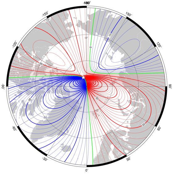
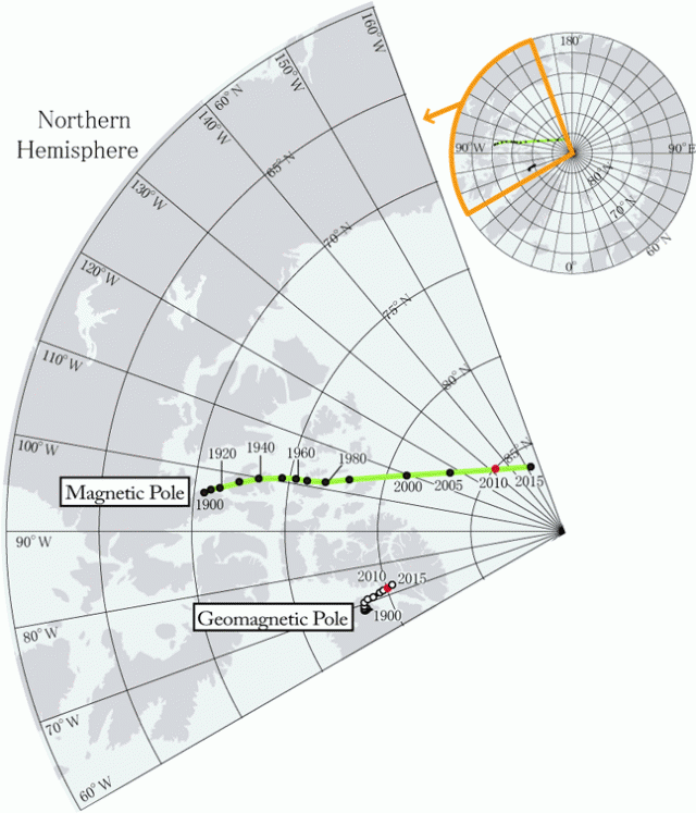
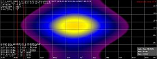
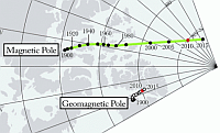
Navigation near the magnetic
north pole
Be careful
not to follow your compass to the blind : magnetic declination
can be above 40 ° and the horizontal component is weak...
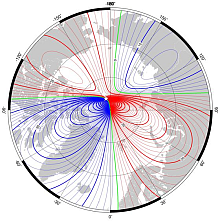
Source : http://www.geomag.bgs.ac.uk/education/earthmag.html
- Declination
(magnetic variation) in region of north pole at 2015.0 from
the World Magnetic Model . Red - positive (east), blue - negative
(west), black - zero. Contour interval is 5°.
Source : Geophysical Institute – University of Alaska
– Fairbanks - http://gse.gi.alaska.edu
Aurora
borealis - northern lights
Forecast
... click on the picture
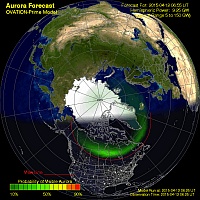
Source image : NOAA space weather prediction center
It still has to be dark (see
nautical twilight, definition)
Bibliography
Culture
- Paul Emile Victor, Joëlle
Robert-Lamblin, La civilisation du phoque, Tôme 1,
éd. A. Colin & R. Chabaud, 1989
- Paul Emile Victor, Joëlle
Robert-Lamblin, La civilisation du phoque, Tôme 2,
éd. R. Chabaud, 1993
- Jean Malaurie, L'appel du
Nord, éditions de La Martinière, 2001
- Jean Malaurie, Ultima Thulé,
édition Bordas, 2000
- Qunerseeq Rosing, Inuit -
my photographs. Pictures from Greenland 1959-92, ISBN 8790133579
- B. Klin, D. Duard, Le Bateau
Igloo, éditions Arthaud, 1994
- Jorn Riel, Soré - Sangen
for livet 1-3, Lindhardt og Ringhof, 1985 (english translation
available)
Sailing directions
- Admiralty Sailing Directions,
Arctic Pilot Volume II
- Admiralty Sailing Directions,
Arctic Pilot Volume III
- Sailing directions PUB.181,
Greenland and Iceland, U.S. National Geospatial-Intelligence
Agency
- Pub.180, Sailing Directions Planning Guide Arctic Ocean,
U.S. National Geospatial-Intelligence Agency
- Willy Ker, Christopher Thornhill,
Faroe, Iceland and Greenland, Royal Cruising Club Foundation,
Imray, 1998
- RCCPF
/ Andrew Wilkes, Arctic and Northern Waters, RCC Pilotage
Foundation, Imray, 2014
Gateways
Source
of flags : Wikipedia
Friends
* * * |