
| The Imram Voyage 2003 to Iceland & Greenland |
|
The ideal way to visit the 3000 km long East Coast of Greenland is by boat, facilitating and enhancing contact with the environment and its inhabitants in the process. This journey was inspired by the legendary voyages of the 5th century Irish monks who crossed the North Atlantic, the incredible 7-year odyssey of Brendan taking him probably to Greenland and Newfoundland, the 19th and 20th century Arctic exploration, particularly by Commander Charcot in the Pourquoi Pas, the ethnological expeditions of Paul Emile Victor in the 1930s, and most recently the Vagabond expedition. The attraction of these isolated areas is the same for us as it was for those voyagers. There are still white patches on maps even in the GPS and Internet era. Add to this the fascination of the Inuit culture, which has switched in one century from a traditional way of life to embracing modern technology and comfort, but is now having to deal with the environmental problems resulting from global warming. This expedition was undertaken by a group of 16 highly motivated yachtsmen and mountaineers, in 5 teams, with no sponsorship but with the practical help of many others. It demonstrates that such a voyage can be accomplished under excellent conditions of comfort and security, thanks to improvements in naval construction techniques and navigational and communication equipment. One month after departing from St Malo on 26 June and making good progress via the Irish Sea, Scotland, the Faeroe Islands and Iceland, “Imram” was slowly approaching the East Coast of Greenland.
What at first seemed to be cumulus clouds on the horizon slowly reveal themselves as the summits of Greenland’s East Coast. Deformed by a mirage effect due to the very cold water, these 2000 m peaks can be seen well over 100 km away. The air is so pure it seems you could almost touch them. Slowly the layer of stratus that has accompanied us since we left Reykjavik 3 days ago gives way to warm sunshine. A gentle northerly breeze pushes us along. A few seconds before the sun rises, the night watch witnesses a “green ray”. Our physicist, Rob, spends the day elaborating all sorts of complex theories to explain this rare phenomenon, but we remain unconvinced. We all come up on deck for a sunny breakfast of salmon, fresh bread and coffee. The ice map recorded the previous evening indicates a belt of ice reaching out 20 miles from the coast. However, as we get nearer we discover that the ice has broken up and we see, film and photograph our first big icebergs, often higher than the mast but easy to avoid.
After passing Cape Dan we discover the entrance to Kong (should it be King?) Oscar Havn. There sheltered in a tiny cove crowded with all sorts of motor boats is Tasiilag, the capital of Greenland with its 1800 inhabitants out of a total populations of 3000. For 2 days Imram is the centre of attraction of the harbour, and the numerous visitors bring us plenty of useful advice for the next stage of our voyage. After stocking up on provisions and sampling the public showers, we set off for Sermilik Fjord. The weather is fine and we motor along amid a mass of icebergs as far as Tinitequilaq. Hardly have we tied up to the rusty quayside rings than a French photographer greets us. He tells us that the last time that a sailing boat stopped here was 14 years ago. With his help we make the acquaintance of an Inuit who has just returned from hunting a narwhal. Proudly he shows us the amazing single spiral tusk. Not for the first time we regret our complete inability to speak the Inuit language. It feels that we have changed era: the absence of cars, the smell of fish and seal meat drying in the sun, the bark of a dog, and then complete silence. Next morning we set off up Sermilik Fjord zigzagging between icebergs and rocks not marked on the chart. Frequently small blocks of ice brush against the side of the hull. One of the crew climbs the mast and indicates from the crow’s nest (?) the best route through the icy labyrinth. Weather conditions are perfect, not a breath of wind, and the sunshine gives the sea and icebergs a surrealist polarized appearance. A few miles from the head of the fjord we unload our hiking team, plus all mountain equipment, tents and provisions for a 4-day trek.
On the advice of Sören, a Dane speaking perfect French who settled in Tasiilaq in 1964, we anchor in a small bay. At low tide we leap from one granite slab to another searching for the famous Arctic mussels. Later on, accompanied by a risotto and a bottle of white wine, the taste is delectable. The following morning, the sun is already high in the sky when we are awoken by Ulrich, an Inuit fisherman who comes on board. Switching readily between Japanese, German and English, he tells us about the expeditions currently taking place in the area. As he leaves he offers us two magnificent cod, a very welcomed gesture as gastronomic planning is one of our major onboard preoccupations. We receive a radio call from the trekking team asking us to hurry to the rendezvous site as they have experienced a series of minor problems. The group of tired trekkers comes aboard Imram in the afternoon, and a rest day allows them to recover while the yachtsmen stretch their legs on land. Two days later the mountaineers among us get ready for a 4-day camp at the foot of the Karale Gletscher and the exploration of an unnamed range on its south side. We find a suitable anchorage and leave the mountaineers to set up camp at a perfect spot beside a lake and stream. The accuracy of our map is very approximate: only 20 years ago we would have been standing at the foot of a huge glacier and today we are 5 km from it! The view is superb and the conditions perfect - apart from the midges. The yachtsmen decide to visit, 60 miles further north, the winter camp of Paul Emile Victor, the French ethnologist who explored the region and its people in the 1930s. The site is abandoned and silent, but somehow we don’t feel alone and wouldn’t have been surprised to see Oumiak arriving full of women and children, followed by kayaks bringing home the hunting rewards of the day.
We continue northwards. A strange paradox because we continually come across Inuit hunters moving southwards now that their hunting season has ended. Summer too is coming to an end and night-time has returned. Although ice is not a navigational problem it is a risk for Imram, especially the small chunks that are hardly visible yet heavy enough to damage the propeller or rudders. The other danger comes from the rocks and islets that are generally not marked on the charts. Apart from the region of Ammassalik the best chart scale we have is 1: 400,000 and in general there are no depth indications for sea areas less than 8 miles from the coast. There are only three lighthouses for the 3000 km of the East Greenland coast and one of these, at the entrance to Ammassalik, is only visible up to a distance of 7 nautical miles! Visibility is crucial since there can be as much as a mile of difference between our position according to the GPS and the map. In this situation the radar is extremely useful and allows us to detect small blocks of ice as long as there are not too many and the sea is calm.
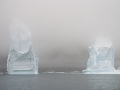
After 24 hours of sailing we approach Kangerdlugssuaq, a fjord about the same size as Sermilik and around 200 km north of Tasiilag. The entrance to the fjord is fringed by black mountain cliffs, immense glacier snouts that flow into the sea and floating ice cathedrals that disappear in the mist and the twilight. The sea is a metallic grey, and the only relief in this sinister, monochrome landscape is the orange colour of Imram’s centre-boards. A swell from the south-east causes the less stable icebergs to tip over. It is both impressive and nerve-racking to see house-size icebergs turning, plunging and emerging in the swell and colliding with one another only metres from our hull. We manage to thread our way between icebergs and rocks, only to discover that our intended anchorage is full of ice. We are exhausted and frozen, rain is falling and night approaching. We must find shelter! But luck smiles on us and we find a little cover nearby where we stay for the next few days. During an initial reconnaissance we discover the trace of earlier mountaineering and geological expeditions in this area rich in mineral deposits. We also come across an abandoned village with a considerable store of fuel, handy should we be forced to over-winter in the area. However our hearts sink at the state of the village. The rocks are covered with a thick layer of stinking seal fat mixed with all sorts of rubbish. Still, it’s a real open-air museum illustrating the hardships of life under these extreme conditions. More than ever, the solitude of the abandoned village hits us. We use one of our spare days to reach an unnamed summit nearby. Not a difficult climb, but cut off from the rest of the world we can count only on our own resources. This is life at its fullest.
With the end of the Arctic summer comes the smell of snow. The clouds are low and the summits of mountains and icebergs are shrouded in mist. The weather is deteriorating day by day and it is high time for us to leave. We motor out in a light wind which slowly increases to force 6-7 and occasional gale force. With two reefs in the main sail and a storm jib, Imram steams along. The speedo needle doesn’t go below 8-10 knots. Waves submerge the deck regularly, but the boat remains perfectly balanced and with the autopilot performing reliably we can keep watch from the covered cockpit. We still come across ice until we are within 50 miles of the Icelandic coast. Although we can see icebergs from miles away, smaller blocks of ice are difficult to distinguish from the foam of the breakers and we only see them at the last moment. The radar chooses just this moment to pack up.
Around 260 miles and 28 hours later, we enter the sheltered fjords of N.W. Iceland and rediscover the luxuriance of the plant life, the sound of streams running through the peat, the smell of the earth and the taste of bilberries.
Original text: Peter Gallinelli ACAPELA, nov 2003 - Integral 12m50 Sailboat |
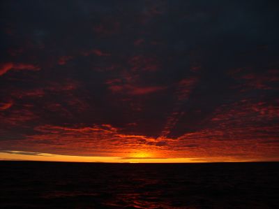 Sunrise & sunset on the Greenland Sea
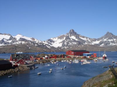
 Tinitequilaq in Sermilik Fjord
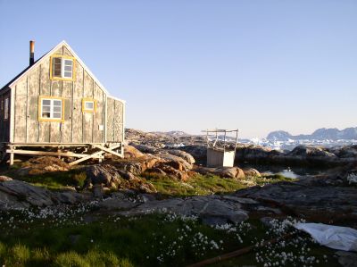
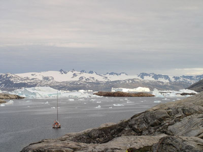 Mooring in the Sermilik Fjord
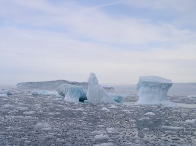 Close to the Steenstrup glaciers
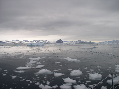 Approaching Kangerdlugssuaq Fjord
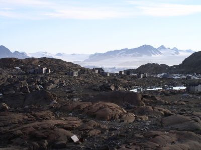
 Icebergs in Mikis Fjord